
The Hoapili Trail is an ancient road made of lava rocks built to facilitate travel, communication, and trade on Maui.
It is also the location of one of Maui’s most stunning hikes and an opportunity to witness a bit of Hawaiian history.
How Old Is The Hoapili Trail?
Table of Contents
The Hoapili Trail was originally known as the Pi’ilani Trail, a footpath along the coastline built in the 16th century.
The trail was named after King Pi’ilani, the first ruler to unify the competing districts of Maui and known for bringing peace and prosperity to the island.
The original trail is believed to have looped the entire island.
A section of the Pi’ilani Trail in South Maui was later rebuilt in the 1830s by orders of then Governor Hoapili, who widened it to allow horses and carts on the path.
What Was The Hoapili Trail Used For And By Whom?
Prior to the construction of the trail, natives would travel by canoe between coastal villages, but as more people settled in the uplands, an easier way to travel to the remote areas became necessary.
As the nickname “King’s Highway” or “King’s Trail” suggests, its use was reserved to the ali’i (Hawaiian royals) to travel around from coastal villages to the uplands, giving the king access to all parts of his kingdom.
It allowed royal messengers to quickly get from one part of the island to another, helping connect people, making trade and collecting taxes easier, as well as protecting the then peaceful island of Maui from possible attacks.
How Did They Build The Hoapili Trail Originally?
The ancient Pi’ilani Trail was built by native Hawaiians using ‘ili ‘ili stones, a soft, smooth stone with a bluish hue. The stones are known for reflecting moonlight during a full moon so as to make the path discernible at night.
Built in pre-contact Hawai’i, this trail was made for people traveling by foot, since horses were not yet brought to the islands. The original trail was mostly destroyed by various natural disasters such as lava flows and tsunamis.
By the time Governor Hoapili renovated the trail, and the arrival of Europeans had brought horses and mules over, the original ‘ili ‘ili stones were deemed too slippery and the path too narrow for the horses.
The newer trail was therefore made of jagged lava rocks, called a’a’, and widened from 4 feet to 8 feet wide.
How Do You Know If You’re Walking On The Pi’ilani Trail Versus The Hoapili Trail?
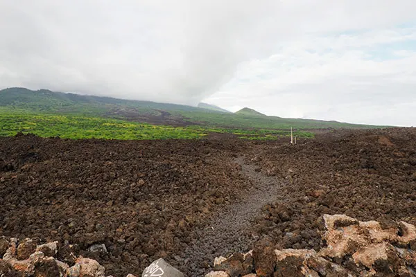
When hiking the trail you can clearly see from the coastline the field created by the lava flow rolling down from Haleakala.
This massive lava flow is the last one to occur on Maui, with Haleakala’s last eruption estimated around 1790. Therefore, it is fair to assume that a large chunk of the then Pi’ilani trail was covered by lava after the eruption, making it no longer visible.
On the other hand, the Hoapili Trail was built after the last lava flow and is marked by raised curbs on each side of the trail, making it clearly identifiable and much easier to find.
However, if you pay close attention, a few ‘ili ‘ili stones are still visible on the Hoapili Trail, which is quite remarkable after 500 years and being covered by a lava field.
Who Built The Hoapili Trail?
So who actually built this road? If you’re not familiar with the trail or the area surrounding it, maybe this question didn’t pop into your head.
But carrying jagged lava rocks by hand in this dry, deserted area, under the hot sun, with little to no shade, and face slapping gusts of wind, doesn’t exactly sound like a golden opportunity.
As you can imagine, Governor Hoapili didn’t carefully place the harsh lava rocks himself.
Indeed, whoever was put on the job was surely being punished. As a converted Christian, Hoapili recruited prisoners—adulterers in particular—for the hard labor, inspiring the phrase “the road that sin built.”
Is It Still Used By Hawaiians Today?
Today, the Hoapili Trail refers to the hiking trail in South Maui that starts in La Perouse Bay. While it is not used by Hawaiians for everyday travel, the trail remains intact to this day and walking it offers the opportunity to travel back in time, and feel what it must’ve been like to walk in the king’s footsteps several centuries ago.
Although the Hoapili trail stretches along the coast for about 12 miles, the official trail is about a two-mile hike (and two miles back) and ends at Kanaio beach, after which the trail crosses private properties and is not accessible to the public.
Fragments of the Pi’ilani Trail can still be found today in some parts of the island but most of it has disappeared beneath modern roads or has been swallowed by the jungle.
The road is still called by its ancient name, notably the partially unpaved, narrow section of the highway known as “the back road to Hana,” the stretch of road between Kaupo and Ulupalakua, or Highway 31.
So Is It Hoapili Trail, Pi’ilani Trail, King’s Highway, Or La Perouse?
It’s all of the above.
Although remains of the Pi’ilani Trail are still visible in some parts of the island, the Hoapili Trail refers to the one section in South Maui that was built over the ancient trail after the last volcanic eruption destroyed it.
The King’s Highway generally refers to the ancient Pi’ilani trail, and what is left of it, which also includes the Hoapili Trail.
As a general rule, people also refer to the trail as La Perouse because the trail goes along La Perouse Bay, where the road for modern cars ends, and the historical trail begins.