
It’s hard to remember sometimes that a visit to Maui is technically a visit to two volcanoes. Despite dominating the landscape, Haleakala seems far away from the world of eruptions.
But if you want to feel closer to the awesome power of Haleakala, take a trip to the Lava Fields. This South Maui hiking trail is an up close exploration of how the volcanoes formed Maui.
The Maui Lava Fields history gives visitors a glimpse into how Maui came to be. Read this guide for the best ways to discover it for yourself.
Where Are The Lava Fields On Maui?
Table of Contents
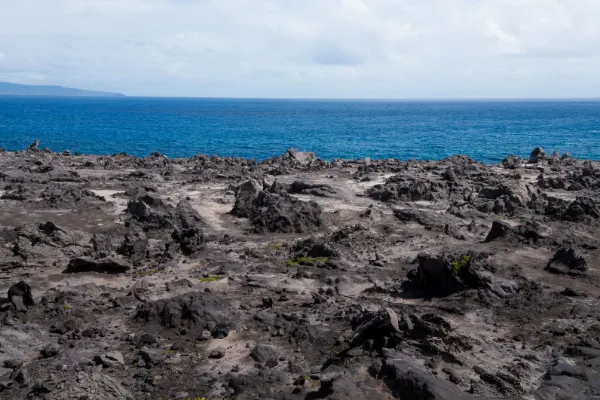
A natural formation that feels like a step into another world, the Lava Fields are a Maui landmark found on one of the southernmost areas of the island.
Past the hotels of Wailea and the beaches of Makena, the Lava Fields are the starting point of a hike that passes through a part of Maui like no other.
How Do You Get To Maui Lava Fields?
A car is necessary to access the Lava Fields, as you need to head into Makena State Park. The Lava Fields are roughly a 30-minute drive from Kihei, and you get to watch as the pristine hotels of Wailea give way to a rugged natural landscape.
Driving southwards from Wailea, follow the Wailea Alanui Drive until it becomes Makena Road. Follow the road as it pulls past Big Beach and hugs the Maui coastline.
Pass Big Beach, and keep following the road. You’ll recognize when you’ve reached the Lava Fields because the scenery changes from white beaches into a black landscape that looks like the setting of a science fiction movie. The area is closed for walkers, but you can still drive through. Drive slowly as the curving road can mask oncoming traffic.
Once you’ve passed through the Lava Fields, you’ll find yourself at La Perouse Bay. Park here to take the Hoapili Trail, and discover the Maui lava trail.
Maui Lava Fields History
The land mass of Maui is made up of two massive volcanoes. Or, more accurately, one massive volcano, and one slightly smaller volcano. More than three quarters of Maui is Haleakala volcano, with the remaining quarter being formed by the West Maui Mountains (otherwise known as Mauna Kahalawai).
Much of the Maui landscape was formed by volcanic eruptions. The resulting lava flows hardened to create Maui’s most iconic features. The Dragon’s Teeth, Black Rock, and Ke’anae Point were all formed by more recent lava flows.
The last eruption from Haleakala was thought to take place around 1790. This lava flow poured from the side of Haleakala, and eased its way towards the sea. In the centuries since it hardened to form the jagged rocks and black sands of the Lava Fields.
The Hoapili Trail is also a part of Maui history, originating when the only way to travel the island was by foot. Hiking the trail remnants can give you some idea of what it was like to live on historical Maui.
Is There Active Lava On Maui?
You might leave the Maui Lava Fields feeling a little warm, but this is only because of the sunny skies and lack of shade.
The last time active lava reached the Lava Fields was the 1790s.
Drive slowly through the lava fields, and passengers can actually spot where on Haleakala the eruption originated.
Hoapili Trail
To pass through the Lava Fields of Maui, head for the Hoapili Trail. This coastal trail is a mostly flat walk, making it one of the easier hikes on the island. The round trip takes you across the lava trails to the edge of the island, and then back again.
The Hoapili Trail stands out due to the unique scenery that greets you in every direction you turn.
Face out to sea and spot the rugged edges of lava giving way to the clear waters of Maui. Turn around, and you can spy the so-called backside of Haleakala.
Hoapili Trail takes roughly 2 hours to complete at a decent pace. But take snacks and be prepared to stay for longer—the Lava Fields are worth exploring.
La Perouse Bay
La Perouse Bay has become almost synonymous with one thing, dolphins. These cheeky creatures regularly visit La Perouse Bay to catch up on their sleep, which they do with only half a brain.
Visitors to La Perouse Bay are allowed to swim, but must stay at least 50 yards away from the dolphins.
Hanomanioa Light
There are two potential end points to the Hoapili Trail: Hanomanioa Light, and Kanaio Beach. The path diverges to either cut through the land or follow the coast, depending on where you want to go.
Hanomanioa Light is the first stopping point.
The trail spreads outwards towards the coast, leading you to a small light that marks the far south of the island. There’s a rocky beach area here to sit and soak up the views before you tackle the walk back.
Kanaio Beach
The farthest point on the trail is Kanaio Beach. Sometimes referred to as the King’s Highway, the walk to and from Kanaio can be an all day trip.
At roughly 5.5 miles, the King’s Highway takes around four hours there and back. And that’s not factoring in all the times you’ll stop for photos!
What To Wear For Hiking The Lava Fields
Although there might not be any active lava on the Lava Fields, the ground can still get hot. These are black rocks, sitting out in the sun all day, soaking up all the heat. Dress in loose and comfortable clothing, and bring plenty of water.
Thick soled shoes are also a necessity. The lava rocks are sharp, and can pierce their way through a pair of cheap flip-flops. Sandals are best avoided as well. Bits of the lava rock can sneak into sandals, and those sharp edges are hard to ignore.
Should You Visit The Lava Fields?
There’s almost nowhere else in the world that has a scene like the lava fields.
The jagged rocks and wild textures are almost completely unique to Hawaii, and create a scene of rugged beauty.