
One of the few waterfall hikes not on the Road to Hana, Makamaka’ole Stream Hike is a moderate trail characterized by a series of river crossings.
Slightly off the beaten path, this is a relatively popular hike that rewards perseverance with two waterfalls, and a bamboo trail.
Plan your hike at the Makamaka’ole Stream trail with our guide.
Where Is The Makamaka’ole Stream Hike?
Table of Contents
The Makamaka’ole Stream hike is in Central Maui, and is one of the easiest hikes to access from West Maui. Accessed via the Kahekili Highway, the Makamaka’ole Stream Hike encompasses a (mini) bamboo forest, a banyan tree, and finishes with a chance to see two waterfalls.
For visitors who don’t want to travel the Hana Highway, this hike is like a small slice of East Maui, closer to your doorstep.
Getting To Makamaka’ole Stream Hike
The trailhead for the Makamaka’ole Stream Hike starts on the Kahekili Highway. Follow the road until you pass over the bridge spanning the Makamaka’ole Stream.
There’s a small shoulder area to the south of the bridge, which is the best place to park. Further along the road there are a few places to pull in, but keep in mind you’ll have to walk back to the trailhead.
The Kahekili Highway has a reputation for being difficult, and it’s well-earned. There are many twists and turns, and blind corners can catch drivers unaware. At several points the road skirts the cliff edge.
The trail starts right by the bridge over Makamaka’ole Stream. Look for the entrance to the south of the bridge, at the start of the shoulder.
How Long Is The Makamaka’ole Stream Hike?
The Makamaka’ole Stream Hike is roughly a 2-mile hike, out and back. It takes most visitors between 1 and 2 hours to complete, depending on the conditions of the path.
The trail has a moderate elevation gain of 400 feet. Not the worst on Maui, but still not easy going.
Following The Hike
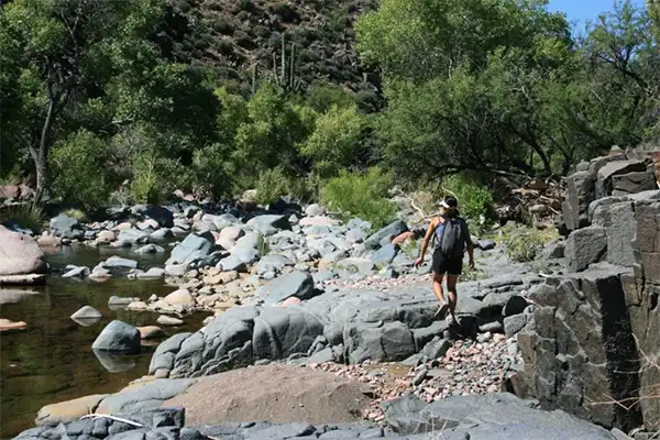
Shortly after starting the trail, the path leads you down to the river basin. Follow for just a short while, and you’ll come to a banyan tree, and the first crossing. Climb carefully over the stream, and keep following the path along.
Makamaka’ole Stream Hike is characterized by these river crossings. There’s 13 of them, which is how the trail got the nickname 13 Crossings.
As the trail follows the stream, you’ll need to cross from side to side to keep up with the path. Depending on the height of the stream, these crossings can be easy, or they can be very damp!
Wet feet are basically a guarantee on this trail, unless you’re incredibly sure-footed.
Makamaka’ole Bamboo Forest
The trail winds along the stream, passing some notable features along the way. A mini bamboo forest is one of the highlights of the trail.
It can’t quite compare to the larger bamboo forest of the Pipiwai Trail on East Maui, but it’s still pretty spectacular. If there’s a breeze, stop and listen to the bamboo stalks as they bump together. It’s very zen.
Makamaka’ole Falls
The trail ends at a fork. Both take you to a waterfall, and we recommend making time to explore either direction. But if you can only do one, head right.
Following the right fork takes you to the main falls, which cascades into a deep pool. There’s often enough water for a swim, or at least a quick dip. Sit and take in the atmosphere for a minute, before heading back to the main trail.
Now, follow the left fork. This leads you to another fall, with a smaller pool and (potentially) a smaller crowd.
There are some additional trails appearing to lead off at this point, but they aren’t very well-marked. We recommend treating the waterfalls as the end of the trail, and turning around.
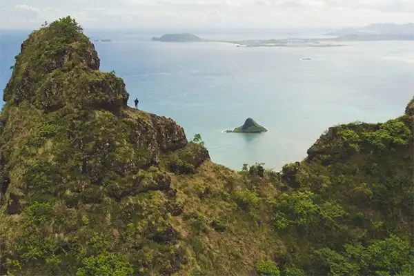
If you want to carry on hiking, head back to the road and take a short drive to the Waihe’e Ridge Trail. A moderate trail, there are fewer waterfalls, but you do get panoramic views of West Maui.
Expert Tips For The Makamaka’ole Stream Hike
Like the sound of a bamboo forest and waterfall hike? Check out our expert tips:
- Wear water shoes. As you frequently have to cross over the stream, you can expect your feet to end up in the water at least once. The rocky crossings require sturdy footwear, so this is not a trail to attempt in your sandals.
- Hiking poles are highly recommended to help with those 13 crossings that give the trail its name. The path can be slippery even after a period of dry weather, and the path either side of the trail is rarely smooth walking.
- Makamaka’ole Stream Hike mostly passes through shade, which can be blissfully cooling on hot days. That said, make sure to pack a good amount of water, and some snacks to keep you going. The hike isn’t the longest distance, but mastering those crossings can take it out of you.
- Bring a towel! There’s often enough water in the plunge pools for a swim, or at least a chance to dip your feet. Not to mention, you’ll probably be damp from the hike.
Is Makamaka’ole Stream Hike Safe?
There is a risk of flash flooding on the Makamaka’ole Stream Hike, so always check the weather conditions before you go.
If it’s been raining heavily in recent days, or there’s a lot of drizzle, skip the hike. Don’t risk getting caught in a flash flood.
It gets dark a little earlier on Central Maui, so we recommend Makamaka’ole Stream as a morning or midday hike. Remember, once the hike is over, you still have to tackle Kahekili Highway.
Final Thoughts
The 13 Crossings of Makamaka’ole Stream Hike can be hard work, but with waterfalls and a bamboo forest, this is a touch of the Road to Hana for those on West Maui.
Take your time on the crossings, and then see your journey from a distance on the Waihe’e Ridge Trail.